日常的に地図を見る機会といえば、天気予報で見る日本地図くらいしか思い浮かばない人が大半だと思います。
見方や視点で大きく変化するのが地図というものなので、見慣れている日本でも見方を変えると見慣れない地図に変貌したりします。
見方や視点がちょっと違う地図をいくつかご紹介します。
The United States of America: Alaskan perspective from r/MapPorn
https://www.reddit.com/r/MapPorn/comments/d3ti88/the_united_states_of_america_alaskan_perspective/
アラスカ州の一般的なアメリカ地図は、当然のごとくアラスカが中心となっています。
Roads either side of the border: Finland vs Russia from r/MapPorn
https://www.reddit.com/r/MapPorn/comments/ab23m2/roads_either_side_of_the_border_finland_vs_russia/
フィンランドとロシアの国境付近の道路図。あからさまに道路の数が違うのは、国土の広さが関係しているのでしょうか。
[OC] The topologist’s map of the world –a map showing international borders, and nothing else from r/MapPorn
https://www.reddit.com/r/MapPorn/comments/gxwn5r/oc_the_topologists_map_of_the_world_a_map_showing/
位相幾何学者(トポロジスト)による世界地図。日本がどこにあるか見つけられますか?
The Japanese flag but the two colors have the same population. from r/MapPorn
https://www.reddit.com/r/MapPorn/comments/iixpt7/the_japanese_flag_but_the_two_colors_have_the/
見慣れた日本地図。都道府県別に国旗の色でもある赤と白の2色で区別されています。これは関東を含む赤く塗られた都道府県の人口と、白く塗られた都道府県の人口が同じであることを示した地図なんです。
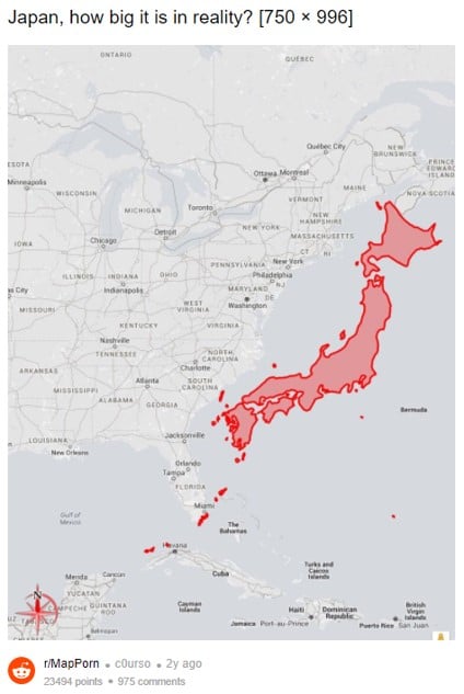
https://www.reddit.com/r/MapPorn/comments/7bv8un/japan_how_big_it_is_in_reality_750_996/
緯度とサイズを合わせた日本地図とアメリカ東海岸の地図を並べてみました。日本とアメリカ東海岸両方の在住経験がある人にとっては、日本という国がいかに縦に長くて横が短いかを実感できる地図ではないでしょうか。
※画像:Redditより引用
https://www.reddit.com/r/MapPorn/comments/7bv8un/japan_how_big_it_is_in_reality_750_996/
(執筆者: 6PAC)
―― 会いたい人に会いに行こう、見たいものを見に行こう『ガジェット通信(GetNews)』


